Geography
Improving urban planning with virtual reality
The impact of structural changes on people can be measured through immersion in virtual models.
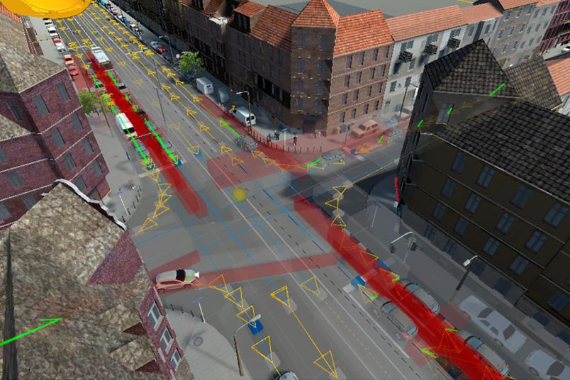
What should the city we live in look like? How do structural changes affect the people who move around it? Cartographers at Ruhr University Bochum use virtual reality tools to explore these questions before a great deal of money is spent on building measures. Using the Unity3 game engine, they recreate scenarios in 3D where people can experience potential changes through immersion. They were able to prove that the physical reaction to this experience is measurable. Julian Keil and Marco Weißmann from Professor Frank Dickmann’s team published their findings in KN – Journal of Cartography and Geographic Information on 1 May 2023 and in Applied Sciences on 13 May 2023.
Lab kit for urban scenarios
Construction measures that transform urban settings change the environment of both the people who live there permanently and those who visit them temporarily. It’s not always possible to foresee the effects in advance. In such cases, it helps to recreate the setting in a 3D model which people can experience through immersion. To this end, the cartographers working with Marco Weißmann use software that was originally designed to programme computer game environments. “We’ve developed a lab kit of sorts in which you can simulate an environment virtually, complete with traffic,” explains Weißmann. The researchers can use it to directly visualise the effects of planned structural changes: how does the traffic flow? Do cars and pedestrians get in each other’s way or not?
Measuring the implicit effects of spaces
Moreover, the space that surrounds us affects our well-being. We do notice it sometimes, but not always. “People who’ve lived on a noisy street for a long time, for example, might think they don’t even hear the noise anymore,” says Julian Keil. “But we know that, objectively speaking, residents in such streets experience significantly higher stress levels than others.” In order to determine such implicit effects of urban planning measures before a lot of money has been poured into them, the cartography team developed a method to measure them in advance. For this purpose, they programmed an urban environment in virtual reality and had test participants experience the scenarios. At the same time, they measured the skin conductivity of the test persons, which provides information about their stress level.
They showed that a higher traffic volume in a street clearly upset the test persons, as measured by their skin conductivity. To corroborate their findings, a study is planned to incorporate more physical measurements that will provide information about the participants’ stress levels and various emotions, including heart rate, blood pressure and pupil size. “Until now, residents and other stakeholders have been involved in the planning stage of construction measures, but only in the form of surveys, i.e. explicit statements,” says Keil, whose background is in psychology. “Our method enables spatial planners to assess implicit effects of possible measures and to include them in the planning, too.”
Climate-friendly experiments
The experiments for both studies were conducted in a climate-friendly way using electricity from a mobile solar system on the roof of the institute building.